Forest area calculation is a core activity in the management, planning, and protection of forest resources. However, traditional surveying methods are often time-consuming and prone to errors due to complex mountainous terrain and steep slopes. The emergence of advanced 3D scanning technology provides a breakthrough solution, helping accurately extract the planted forest area ratio as well as the entire natural forest area, while saving up to 70% of calculation time compared with manual processes.
Forest area calculation is the process of determining the total area of a forested region within a defined boundary, typically expressed in m², ha, or km².
Based on their origin, forests are divided into two main types: natural forests and planted forests. The key purposes of calculating forest area include:
When calculating forest area, field surveying methods still play an important role but often face many limitations when surveying large forest areas, especially in locations with steep terrain, difficult access, and dense vegetation.
A large number of measurement points increases the time, cost, and labor required, while the collected data is often fragmented and difficult to consolidate, reuse, or update when forest conditions change.
Therefore, the challenge is how to calculate forest area quickly and accurately while also collecting a sufficiently detailed spatial dataset that can be processed and utilized for various purposes.
.jpg)
To overcome these limitations, 3D scanners integrating LiDAR technology and SLAM have emerged as powerful tools for modern forestry.
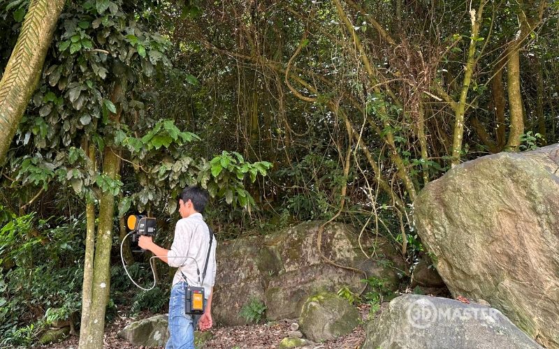
A LiDAR and SLAM-based 3D scanner can continuously collect large volumes of data points as the operator moves through the survey area, thereby supporting forest boundary identification and forest area calculation.
The advantage of this method is its ability to rapidly collect spatial data across large areas while accurately recording terrain and forest structures in 3D. This helps reduce the workload involved in forest area calculation by up to 70%. In addition, this solution can provide significantly higher accuracy than forest scanning using drone-based photogrammetry.
In addition to forest area calculation, the collected 3D data can also be further processed to extract other information for forest inventory and analysis, such as:
When 3D scanning is combined with GIS (Geographic Information Systems) and appropriate map data layers, the forest area calculation process can produce more intuitive results and significantly reduce manual measurement and data consolidation tasks.
This process helps optimize data processing time, transforming raw data into large-area reports in a much shorter time compared with traditional manual methods:
The purpose of this step is to fully capture the spatial shape, terrain, and objects within the forest area to create a 3D dataset for processing, measurement, and analysis.
Tasks to be carried out include:
The result is a Point Cloud dataset representing the 3D spatial environment of the surveyed forest area.
.JPG)
The Point Cloud needs to be cleaned to improve data accuracy and consistency before being used for boundary identification, area calculation, or further analysis.
Tasks to be carried out include:
Note: Point Cloud quality directly affects the accuracy of boundaries and the parameters extracted in subsequent steps.
The purpose of this step is to convert 3D spatial data into a defined area boundary, providing a basis for calculating and managing the forest area.
Tasks to be carried out include:
In practical forest inventory work, forest boundaries and forest conditions are also determined based on maps, remote sensing imagery, and field verification.
Therefore, 3D scanning should be considered an additional data source for collecting spatial information rather than a method that completely replaces existing forest inventory data layers.
This step determines the official area of the forest based on the verified polygon and an appropriate coordinate system.
This method allows forest area to be calculated separately or aggregated across multiple management levels, while also making it easier to update results when boundaries or forest condition data change.
The specific tasks include:
The calculated area can be used for management documentation, forest change monitoring, planning, and subsequent spatial analysis activities.
Yes. Once planted forest areas have been identified, GIS data can be used to calculate the total planted forest area and compare it with the total forest area.
To determine the planted forest area ratio within the total forest area, the following formula can be used:
Planted forest area ratio (%) = Planted forest area / Total forest area × 100
This calculation method can be applied when aggregating data by forest plot, compartment, sub-compartment, or a larger management area.
When area data is available from multiple points in time, the average annual increase in planted forest area can be calculated using the following formula:
Average annual increase = (Final area – Initial area) / Number of years
When surveys are repeated over time, 3D data can become part of a spatial database used to compare changes in forest conditions.
However, to evaluate forest area changes on a large scale, 3D data should be combined with map data, remote sensing imagery, and management records rather than relying solely on a single Point Cloud dataset.

As a pioneering provider in the field of 3D scanning and LiDAR/SLAM technology applications in Vietnam, 3D Master provides comprehensive solutions for surveying, forest inventory, and forest resource digitization.
3D Master’s 3D scanning services help address the challenges of complex terrain, enabling forest management units and forestry businesses to reduce the time required for calculating forest area and forest volume by up to 70%.
Some of 3D Master’s representative projects include:
3D scanning of forests in Thai Binh for carbon credit calculation
.JPG)
3D scanning of an archaeological site in Thanh Hoa
.jpg)
3D scanning of Can Gio Mangrove Forest for carbon credit calculation
.jpg)
3D scanning of Ca Mau mangrove forests for carbon credit calculation
.jpg)
If businesses, forest management units, or research organizations need to calculate natural forest or planted forest areas, survey current forest conditions, or build 3D data for carbon credit calculation, 3D Master can provide consultation on a suitable 3D scanning solution based on the scope, terrain, and data requirements of each project.
In summary, 3D scanning technology enables the rapid collection of spatial data, creates detailed Point Clouds, and supports boundary identification for forest area calculation. Compared with manual measurement methods, this solution reduces surveying effort, minimizes repetitive measurement tasks, and creates a reusable data source for forest inventory, forest structure analysis, and change monitoring. When combined with GIS and appropriate forest condition data, 3D scanning becomes a useful tool for calculating forest area faster, more intuitively, and more efficiently.
3D Master Contact Information: